Idaho BDR
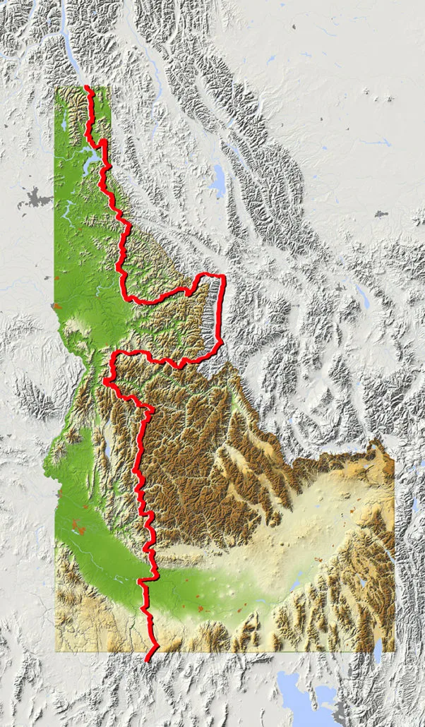
If you’ve ever wanted to ride endless twisty mountain roads, the Idaho BDR will throw corners at you for days on end. You also won’t get many digital interruptions because your cell phone won’t have reception on much of this route. It’s a true off- the-grid ride that is long enough, at 1,250 miles, that you might just use up an entire rear knobby tire.
Starting in the historic town of Jarbidge, NV the route crosses range lands and then heads into the Boise National Forest and treats riders with views of Andersen reservoir and epic alpine camping at Trinity lakes. Tiny towns and treasures like Burgdorf Hot Springs make this a bucket list ride for sure. You’ll travel where Lewis and Clark made history and experience the legendary Magruder Corridor and Lolo Motorway which skirt the roadless Selway-Bitteroot Wilderness. You will reach modest hints of civilization as you pass through Sandpoint, Bonners Ferry on your way to the Canadian Border.
Best time of year: July though October are ideal. Late June can be nice if the snow has melted from the high passes. Watch out for early snow and hunters if you are going in the fall.
The IDBDR project is presented by the Idaho Department of Commerce – Tourism Development, and Big Twin Motorcycles, Idaho’s premiere motorcycle dealership, and the official dealer of the IDBDR.
Idaho BDR
If you’ve ever wanted to ride endless twisty mountain roads, the Idaho BDR will throw corners at you for days on end. You also won’t get many digital interruptions because your cell phone won’t have reception on much of this route. It’s a true off- the-grid ride that is long enough, at 1,250 miles, that you might just use up an entire rear knobby tire.
Starting in the historic town of Jarbidge, NV the route crosses range lands and then heads into the Boise National Forest and treats riders with views of Andersen reservoir and epic alpine camping at Trinity lakes. Tiny towns and treasures like Burgdorf Hot Springs make this a bucket list ride for sure. You’ll travel where Lewis and Clark made history and experience the legendary Magruder Corridor and Lolo Motorway which skirt the roadless Selway-Bitteroot Wilderness. You will reach modest hints of civilization as you pass through Sandpoint, Bonners Ferry on your way to the Canadian Border.
Best time of year: July though October are ideal. Late June can be nice if the snow has melted from the high passes. Watch out for early snow and hunters if you are going in the fall.
The IDBDR project is presented by the Idaho Department of Commerce – Tourism Development, and Big Twin Motorcycles, Idaho’s premiere motorcycle dealership, and the official dealer of the IDBDR.
1. Jarbidge, NV to Glenns
JARBIDGE, NV TO GLENNS FERRY – 111 miles The IDBDR begins just south of the Idaho border in the historic mining town of Jarbidge, Nevada, which is considered one of the most remote towns in America. Jarbidge is tiny population-wise, but it has a gas pump, a restaurant, a motel, and campgrounds north and south of town. Plan on staying the night in Jarbidge and hanging out with the locals.
2. Glenns Ferry to Lowman
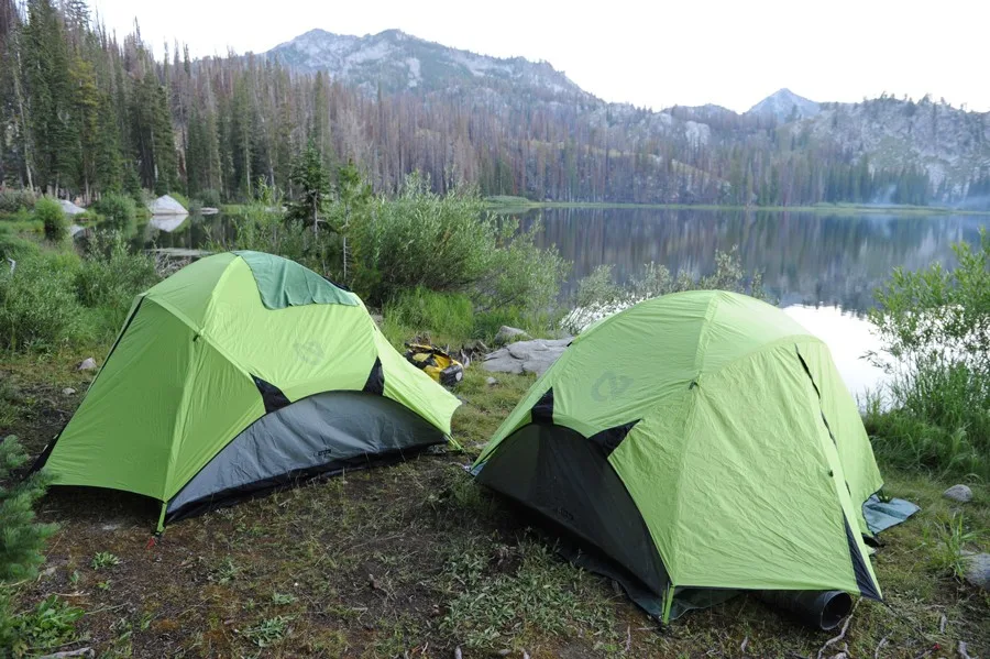
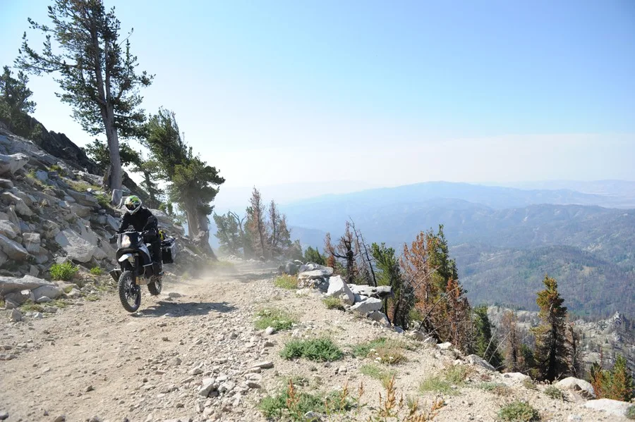
GLENNS FERRY TO LOWMAN – 156 miles From Glenns Ferry, the route crosses over a shoulder of Bennett Mountain, and then heads west on Hwy 20 to a turnoff signed “Anderson Dam Prairie”. After meandering along the shore of Anderson Ranch Reservoir, the route reaches the tiny town of Pine which features gas, a convenience store, and lodging opportunities, and is the only place to fill up until Lowman. Just north of Pine the route begins a dramatic climb into the Boise National Forest and a much different Idaho begins to take shape. From there, the ride is scenic, but slightly grueling with relentlessly twisty gravel roads passing by jagged mountains and alpine lakes. The Trinity Lakes are a must stop with opportunities to rest or grab a campsite for the night. A road continues past the lakes to a gate below Trinity Mountain Lookout. Twisty forest roads continue northward before descending to the South Fork Payette River valley and the town of Lowman with several options for food, gas, and lodging.
3. Lowman to Yellow Pine
LOWMAN TO YELLOW PINE – 93 miles Leaving Lowman, the scenery is spectacular and you’ll ride seemingly endless forest roads with abundant camping opportunities. The twisting descent to Deadwood Reservoir is a riot to ride and the lake is a desirable spot for camping as it has several campgrounds, sandy beaches and an opportunity to go swimming. Farther north, a side trip to Warm Lake offers more camping and rustic log cabins. Almost any time of year you’ll be among friendly outdoorsy folks who use Yellow Pine as a jumping off point for exploring this remote area of Idaho. The small village of Yellow Pine is a true highlight of the trip. If you happen to be here the first week of August you’ll get to experience the Yellow Pine Harmonica Festival. The town has just about everything you need to stock up on food and provisions at the general store in the heart of town.
4. Yellow Pine to Elk City
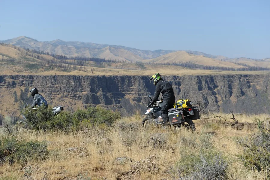
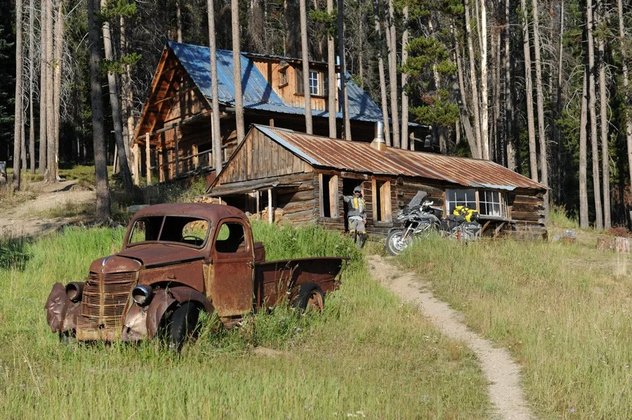
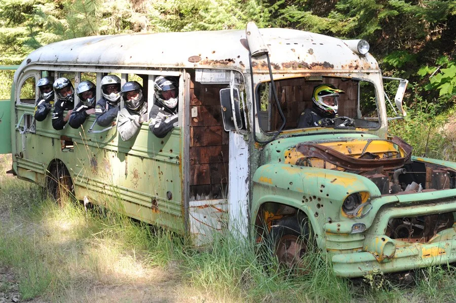
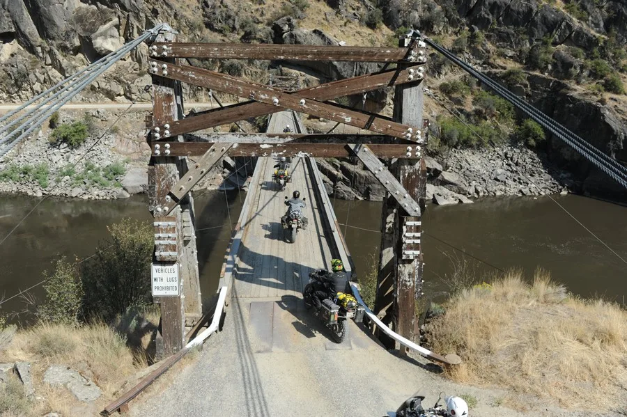
YELLOW PINE TO ELK CITY – 205 miles You are now in the heart of Idaho’s backcountry along the edge of the Frank Church River of No Return Wilderness. The roads are much like what you experienced further south but there are a few incredibly interesting places that make this section of the BDR extremely unique. After crossing Elk Summit at 8670’ and then crossing the South Fork Salmon River, the route passes through the old mining town of Warren that has been around since the mid 1800’s and has plenty of historic relics to remind you of how life was over 150 years ago. Keep an eye out for the abandoned school bus before you wind down the incredible switchbacks of French Creek Grade to the Salmon River. After crossing the historic Manning Bridge, detour into Riggins for fuel, a meal, or lodging if needed. North of the Salmon River, look for the ghost town buildings and cemetery where Florence once flourished. Beyond there the riding is a mix of meandering dirt roads and pavement leading to the town of Elk CIty, the western portal to the Magruder Corridor.
5. Elk City to Lolo, MT
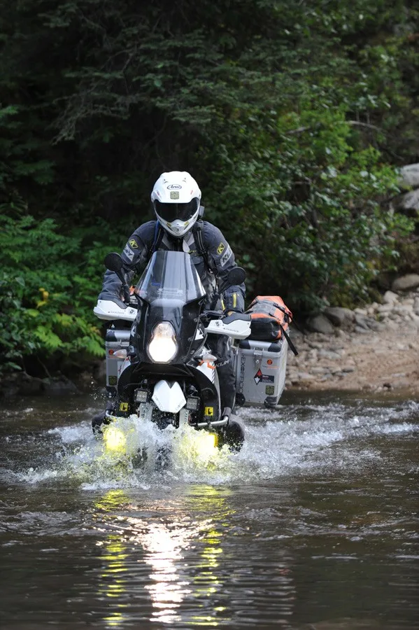
ELK CITY TO LOLO, MT – 178 miles This is the Idaho you’ve always dreamed about: moose, wolves, elk and dramatic vistas. The Magruder Corridor itself runs from the Red River Ranger Station east of Elk City to Darby, Montana and follows a strip of land between the Selway-Bitterroot Wilderness and Frank Church Wilderness. Little has changed on the Magruder Corridor Road (NF-468) since it was built in the 1930s. The road surface itself is not particularly challenging in dry conditions, however, there are no services for about 120 miles and very few people around for help. Expect the ride to take five to six hours without stopping, but we recommend taking your time to enjoy the scenery and viewpoints along the way. The challenging side trip to Burnt Knob (8196’) is short but sweet and highly recommended. There are numerous primitive national forest campgrounds provided along this road. The corridor is typically open from July through September. After reaching civilization in Darby, there is roughly 50 miles of pavement to Lolo and plenty of fuel and lodging options along the way.
6. Lolo, MT to Pierce
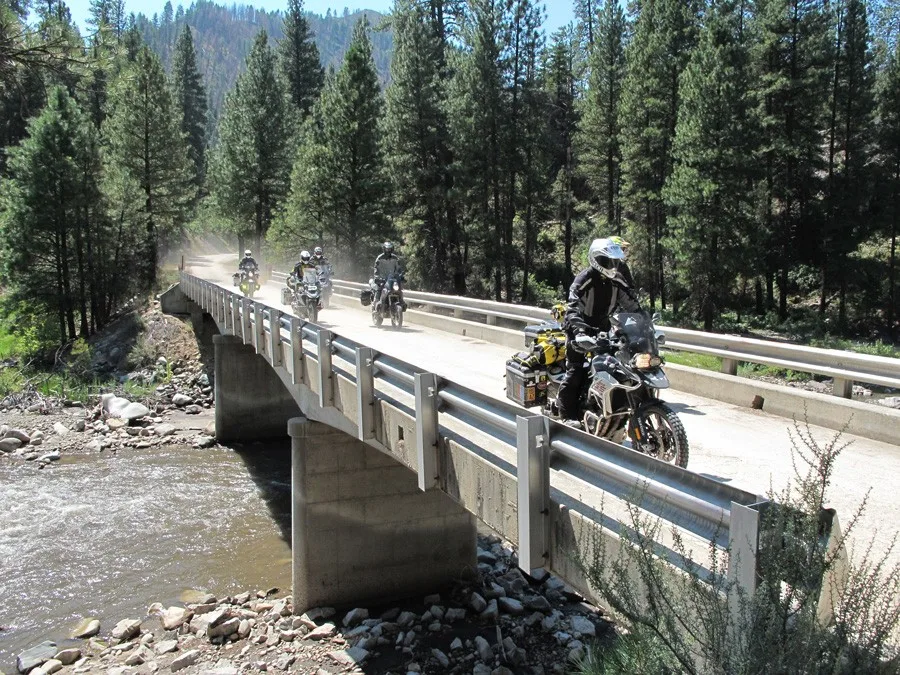
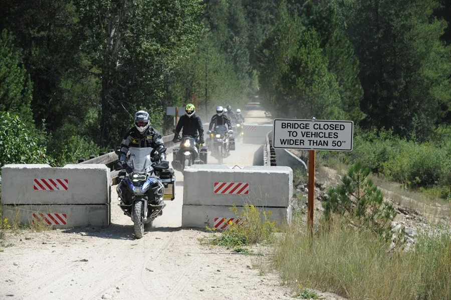
LOLO, MT TO PIERCE – 150 miles Say goodbye to Montana before you turn onto the famous Lolo Pass Highway and head back towards Idaho. The main route branches off the highway to follow dirt roads and bypasses the actual pass on the Montana-Idaho border. If you want to ride some wonderful scenic pavement, just continue on Highway 12 and it will get you to the same place. Either way, you’ll want to stop at Lochsa Lodge. It has a great restaurant, a general store with fuel, a campground, and cabins for rent to regroup before tackling the infamous Lolo Motorway. The Lolo Motorway (road NF-500) follows the path used by the Nez Perce Indians to reach buffalo hunting grounds on the Great Plains. It was also used by Lewis and Clark during their quest to find an inland waterway to the west in 1805. The forest road you’ll be riding is not particularly challenging but is very remote with limited bailouts. Take your time to stop and explore the historically significant spots along the way. This section ends in the town of Pierce which has gas, a grocery store and lodging options.
7. Pierce to Wallace
PIERCE TO WALLACE – 127 miles After leaving Pierce you’ll be entering the Idaho Panhandle and are in for a real treat. The towns in section 7 are some of the quaintest in the state, so take the time to wander around. Along the way you’ll pass by the Blue Heaven Cabin. This rustic shelter is privately owned so take a photo to remember this special place and be on your way. Forest roads climb and descend a few times before reaching the town of Avery. There you’ll have a store with food and fuel and a unique train car with information on the history of the area. Just north of Avery there are two route options. One goes through former railroad tunnels on a wide dirt road and the other is an easy narrow double-track along the eastern shore of the North Fork St Joe River. Both options are worthy of your time and you can do both by looping back as each one is only about five miles long. After crossing over Moon Pass, this road descends to the historic town of Wallace.
8. Wallace to Clark Fork
WALLACE TO CLARK FORK – 106 miles Section 8 begins in the Silver Capital of the world: Wallace, Idaho. Every building in downtown Wallace is on the National Register of Historic Places which is why Interstate 90 had to be built above the town instead of going through it. The ride north from here winds along mellow forest roads, with a stunning canopy of pine trees and ample opportunities for camping. After crossing the Coeur D’Alene River the route rises back up to high ridges. Take a spin up to the Grizzly Mountain summit at almost 6000’ for a magnificent viewpoint. The route also passes right by the crest of Grassy Mountain but it’s about 1000 feet shorter. After many more miles of twisty forest riding the route descends to the charming town of Clark Fork which has gas, and more importantly, a famous bakery known as the Clark Fork Pantry. HEADS UP! This is Grizzly Bear country so camp accordingly.
9. Clark Fork to Canada
CLARK FORK TO CANADA – 102 miles There are only a handful of dirt road options in this narrow strip of land between Washington and Idaho so expect a bit of pavement which may be welcome at this point in your journey. Just out of Clark Fork you’ll head up Lightning Creek Road into Kaniksu National Forest. Be sure to stop at Char Falls which are just a few paces from the parking area and well worth the photo opportunity. Lunch Peak Fire Lookout is also on the way and highly recommended. The route then descends to the shore of Lake Pend Oreille and bypasses the city of Sand Point. If you haven’t visited this lakeside resort city before, consider a detour to check it out. The optional Roman Nose ALT Harder is fairly tame but there’s one short tough section on the ascent up to Ruby Pass. It’s worth the challenge to get to see the Roman Nose Lakes and walk the boardwalk there. On this long optional side trip there are views of Roman Nose, Bottleneck Peak, and other massive granite mountains in Kaniksu National Forest. Soon you’ll alternate between dirt and pavement on your ride north along the banks of the Kootenai River and past the Kootenai National Wildlife Refuge. It’s not long until you reach the north end of the Idaho BDR at the small town of Porthill, Idaho near the Canadian Border crossing.
Interactive map preview
Open the full map for layers, filters, and route planning tools.
Open full mapYour next adventure starts here
Create your own maps with custom routes, waypoints, and layers. Then share with your friends to kick off your adventure planning.
